Project Area
About the Project
Route 981, Section V20 is the last of three projects within the Laurel Valley Improvement Transportation Project Corridor to advance to the Final Design phase. Route 981, Section V20 extends about 3.5 miles from north of the Norvelt intersection in Mount Pleasant Township along Route 2023 to Bingham Road, just south of the intersection of Route 2023/Route 130 in Unity Township.
The project will realign Route 981 beginning at Windy Hill Court following Route 2023 and will include a new bridge over Welty Run and single-lane roundabout at the County Road intersection (visit Section V20 Roundabout Page to learn more). From County Road and continuing north, the alignment will shift east near Klaka Road and Blacksmith Road to avoid sensitive areas. The northern project limit is located at Bingham Road.

Intersection of Route 2023 (Hill Churches Road) and County Road, the future location of a roundabout
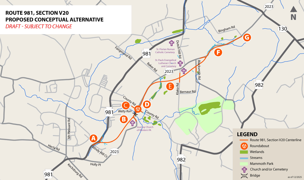
Project Area Map
This map highlights some of the proposed improvements for this project.

A. The project will tie into the Route 981, Section Q20 project with a T-intersection at Route 981 just north of Windy Hill Court.
B. The roadway will continue eastward, off alignment, to connect with the existing Route 2023. The new Route 981 will then follow the current Route 2023 alignment to County Road.
C. A new bridge will be built over Welty Run.
D. A new four-approach, single-lane roundabout will be constructed.
E. The alignment will shift east to avoid St. Paul’s Cemetery.
F. The Alignment shifts slightly east just south of Bingham Road to avoid impacting farmland and a floodplain mitigation area.
G. The northern terminus for the project was moved south to the intersection of Bingham Road and Route 2023 to better tie to the Route 981, Section Y10 Project.
Anticipated Schedule*
Preliminary Design: Complete
Final Design and Right-of-Way Acquisition: 2026 - 2028
Construction: 2029 - 2031
*Schedule subject to change due to funding availability
What is Final Design?
Once Preliminary Design is complete and environmental clearance is received, a project can move to Final Design. During Final Design, the project team will prepare and submit final construction plans including erosion and sedimentation controls, pavement markings and signing, traffic control, and signals. Other Final Design activities include right-of-way acquisition, utility coordination, and final bid packaging.
